

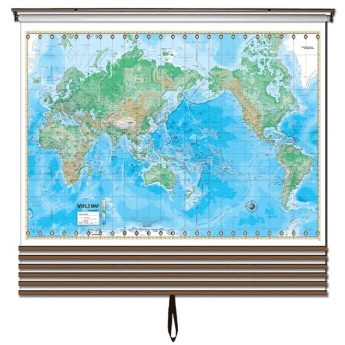
US & World Advanced Physical Classroom Map Pack by BrightWay Educational | 36" x 30" Educational Wall Maps | Grades 9+ | Detailed Geography with Major & Secondary Cities | Geographical & Ocean Features
Product details
| Management number | 211998970 | Release Date | 2026/04/06 | List Price | $20.00 | Model Number | 211998970 | ||
|---|---|---|---|---|---|---|---|---|---|
| Category | |||||||||
Bring geography to life with the US & World Advanced Physical Classroom Map Pack by BrightWay Educational. Designed for grades 9+, this detailed two-map set features shaded relief and vivid color to highlight countries, territories, and key physical features. Land is presented in each map with a colorful elevation ramp, instead of multi-color countries, to aid in the clear understanding of physical features. These maps were designed with teachers and built for students. This Advanced Physical map set includes georeferencing & degree lines, national capitals, major and secondary cities, ocean currents, and bathymetric relief. Perfect for high school and college classrooms, these maps offer a deeper level of geographic detail. Regular updates ensure they’re among the most current educational maps available. Product Features: Bright, vivid colors clearly define countries and territories, making the maps visually engaging for students grades 9+. Grades 9+ Focused: Designed specifically for high school and collegiate classrooms, these maps support Advanced Physical geography instruction. Prominent physical features: Each map uses a colorful elevation ramp instead of multi-colored political borders, making it easier to understand terrain, landforms, and physical geography. Georeference and degree lines offer spatial context, allowing students to comprehend the global grid system and improve map-reading skills. National capitals, major cities, secondary cities, and disputed areas are clearly labeled, offering one of the most information-rich political geography references available for classroom use. Comprehensive physical geography: Includes oceans, mountain ranges, islands, rivers, lakes, and marine features (plus ocean surface currents and bathymetric relief) to support a deeper understanding of both land and water geography. Map Details: World Map (Eckert IV Projection): An equal-area projection that accurately portrays landmass sizes with minimal distortion. Features detailed insets of Europe, Antarctica, and the Arctic, as well as an inset showing all continents and oceans, providing an even broader view of global geography. United States Map (Albers Equal Area): Depicts the U.S. with accurate proportions for all landmasses, ensuring geographical accuracy. Educational Panels: Each map includes additional panels that provide deeper context across key topics: o Population Density: Darker colors represent denser population areas, with major cities clearly highlighted. o Geology & Bedrock: Highlights tectonic plates, volcanoes, and the dominant type and age of bedrock across regions. o Climate Zones: Displays Köppen climate classifications to help students understand global climate patterns and how they relate to geography, ecosystems, and human settlement. Ideal for classrooms, homeschool settings, and learning spaces, the US & World Advanced Physical Classroom Map Pack by BrightWay Educational helps students in grades 9+ explore the world in depth. With shaded relief, elevation ramps, ocean currents, and bathymetric contours, these maps highlight the physical shape of the planet, from mountain ranges and deserts to ocean trenches and river systems. Designed to build spatial awareness and deepen understanding of Earth’s physical structure, this set is a valuable tool for advanced geography instruction.
- Includes one map of the United States and one map of the World, each 36" x 30" and laminated.
- Prominent physical features: Each map uses a colorful elevation ramp instead of multi-colored political borders, making it easier to understand terrain, landforms, and physical geography.
- Grades 9+ Focused: Designed specifically for high school and collegiate classrooms, these maps support Advanced Physical geography instruction.
- Georeference and degree lines provide spatial context, helping students understand the global grid system.
- National capitals, major cities, secondary cities, and disputed areas are clearly labeled, offering one of the most information-rich political geography references available for classroom use.
- Comprehensive physical geography: Includes oceans, mountain ranges, islands, rivers, lakes, and marine features (plus ocean surface currents and bathymetric relief) to support a deeper understanding of both land and water geography.
| Color | Elevation Ramp |
|---|---|
| Map Type | Physical |
| Brand Name | BrightWay Educational |
| Paper Size | 36" x 30" |
| Manufacturer | Map Shop |
| Paper Finish | Glossy |
| Item Dimensions L x W | 36"L x 30"W |


Bestseller ranking
Primers & Drives


Customers who viewed this product also viewed
Maps


Correction of product information
If you notice any omissions or errors in the product information on this page, please use the correction request form below.
Correction Request Form